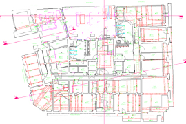
Measured Building Surveys
Measured Building Surveys are often required to facilitate change-of-use building designs or refurbishments, structural alterations, ‘rights of light’ or simply to ascertain the ‘useable’ space within a building. These surveys…
Read more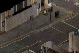
Topographical Surveys
Topographical surveys (Topo) form an essential part of the development process, whether rural, urban or extra urban. Topographical surveys provide an accurate model of the chosen environment, with true elevations and…
Read more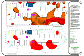
Geophysical Surveys
Geophysical Surveys use ground-based physical sensing technology to map detectable below-ground features, structures and anomalies. We use magnetometry, Electro-Resistive Tomography (ERT) and Ground Probing Radar (GPR), along with other technologies, to…
Read more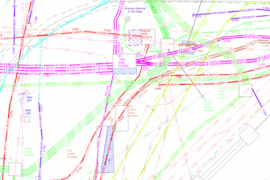
Water Industry: Surveying Services
In the ever-evolving water industry, precision data is the foundation for informed decisions. Whether you’re designing new water infrastructure, maintaining existing pipelines, or addressing emergency repairs, our topographical and utility…
Read more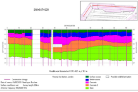
Highway Pavement Surveys
Our unparalleled experience and expertise in the use of towed HDAGPR (High Density Array Ground Probing Radar) solutions has been invaluable to our clients requiring Highway Pavement Surveys. By using…
Read more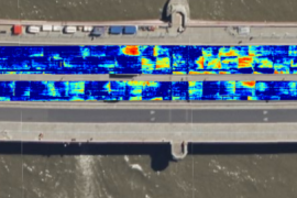
Bridge Deck Surveys
Our unparalleled experience and expertise in the use of towed and hand-pushed HDAGPR (High Density Array Ground Probing Radar) solutions has been proving to be very useful when applied to…
Read more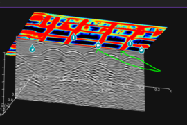
Structural GPR Surveys
Our Structural Ground Penetrating Radar (GPR) Surveys utilises high-frequency ground probing radar to provide detailed and accurate assessments of concrete structures. This advanced technology allows us to detect and analyse…
Read more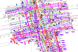
PAS128 Utility Surveys
We are famed for the quality of our award-winning PAS128 compliant Utility Surveys. Whether we are working to a custom specification or the latest PAS128 specification, our mission is simply…
Read more