
Transforming Road Mapping Delivery on Kilburn High Road using NavVis VLX3 Mobile Mapping Technology
03 March 2026 by: Macleod Simmonds
Project Overview
Macleod Simmonds has been proud to support the London Borough of Camden since the very beginning, building a strong and collaborative partnership across multiple highway and infrastructure programmes.
Our latest project on Kilburn High Road began with a dual-discipline commission: a full topographical survey and a comprehensive utility survey along the entire corridor.
While the initial scope was refined to focus on the topographical survey, delivered using the NavVis mobile mapping system, this work played a key role in informing early design decisions and assessing overall scheme viability.
We’re delighted that the utility survey work has since been awarded in phases, allowing us to provide targeted insights in areas where subsurface utilities could impact future design and construction.
The overarching goal remains clear: to create a high-resolution, georeferenced digital model of the highway corridor that will help shape detailed designs for traffic reduction measures and enhanced pedestrian and cycling infrastructure.
It’s exciting to see how high-quality geospatial data continues to drive smarter, safer and more sustainable urban design.
Engineering Challenge
Kilburn High Road is a high-density urban environment with continuous vehicular and pedestrian movement. Conventional survey methods would require prolonged site occupation, creating elevated risks related to traffic interface, public interaction, and the security of high-value survey equipment.
From an engineering and risk-management perspective, a solution was required that reduced time on site without compromising spatial accuracy, data density, or compatibility with downstream design workflows.
Survey Methodology
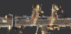
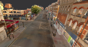
The survey was undertaken using the wearable NavVis VLX3 mobile mapping system. Data capture was completed over two early-morning sessions to minimise interaction with traffic and pedestrians and to improve data quality.
Key technical advantages of this methodology included:
- High-density spatial data capture
The VLX3 system captured detailed 3D point cloud and imagery data across the full highway corridor, accurately recording carriageway geometry, kerb lines, street furniture, building frontages, and surface features. - Reduced requirement for repeat surveys
The completeness of the reality data enabled off-site interrogation of features that would typically require additional site visits, supporting efficient design development and verification. - Design-integrated outputs
Survey data was processed into CAD-compatible formats suitable for highway engineering, urban design, and architectural workflows. Outputs met the specification requirements of the local authority and design consultants. - Programme and risk efficiencies
Data capture was completed in hours rather than weeks, significantly reducing personnel exposure to live traffic environments and lowering the risk associated with deploying conspicuous survey equipment in a high-risk area.
Deliverables and Design Integration
The NavVis dataset was used to produce detailed CAD drawings and fly-through visualisations of Kilburn High Road. These outputs incorporated:
- Full representation of physical highway features
- Accurate elevation data and surface changes
- Defined boundaries and building interfaces
- Street furniture, utilities markers, and highway assets
The model allowed engineers to interrogate geometry, assess constraints, and develop carriageway alignment proposals with confidence, using a single coordinated dataset throughout the design process.

Project Outcome
The adoption of NavVis mobile mapping technology delivered a substantial reduction in programme duration compared to traditional survey approaches. Historically, a project of this scale would require several weeks of on-site survey work, often supplemented by multiple return visits to resolve data gaps.
By capturing comprehensive reality data at the outset, the project team was able to conduct detailed analysis and design development entirely off-site, achieving faster delivery, improved safety outcomes, and high-quality, design-ready CAD outputs.
“I have been incredibly impressed with how Macleod Simmonds have adopted the latest dynamic laser scanning and reality capture technologies from NavVis, to deliver complex topographical and street scene measured information within the city of London and beyond.
The utilisation of NavVis promotes rapid data acquisition, taking millions of measurements every second to generate photorealistic pointclouds and immersive panoramic images that really capture the essence of a place.
Macleod Simmonds can then extract information to draught from, tag Points of Interest, overlay utility records, and share with stakeholders via the NavVis IVION cloud portal, which can be used as a central repository of information.
This means that time on site is dramatically reduced, mitigating risk and disruption through enhanced efficiency, whilst generating comprehensive, accurate datasets for their clients”.
– Martin Harrington, NavVis UK