Introduction
Macleod Simmonds was sub-contracted by FM Conway to undertake an Ultra-Wide Band, High Density Array Ground Probing Radar (UWB-HDAGPR) survey of 25 road bridges and three footbridges, covering a corridor of the M40 spanning almost 52 miles in length.
The M40 bridge deck survey scope and deliverables included:
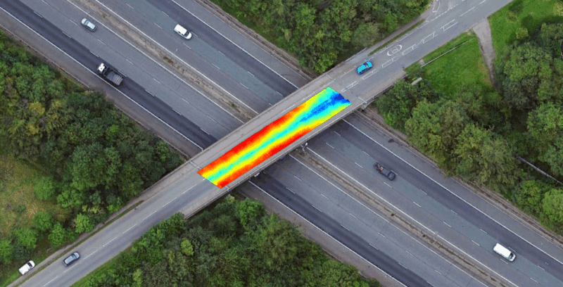
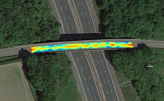
Asphalt thickness profiling across multiple road and foot bridges; Detection of anomalies within pavement and bridge deck structures; High-resolution maps and amplitude models exposing delamination, moisture ingress, and structural inconsistencies.
The Client
Macleod Simmonds was commissioned by FM Conway (on behalf of the National Highways network) to survey the foot and road bridges spanning 52 miles of the M40. FM Conway is an infrastructure services provider and one of the leading manufacturers of asphalt in the South East of England. Its highways maintenance division is a staple of the UK’s road network, providing London and the South of England with an industry-leading service that ensures the roads run smoothly.
The Challenge
The fundamental challenge of this project was working on a network of busy live roads. Closing this network would have delayed the project considerably, impacting cost and road operations. It was also critical that we didn’t utilise a traditional method extracting a core sample from the surface. Not only does this method deliver unreliable results when working across an expansive bridged deck area, it also physically interrupts the carriageway surface increasing the risk of damage to the watertight membrane (which increases the risk of potholes and structural damage).
The Methodology
3D Radar UWB GPR Deployment for road-bridge analysis
A Kontur Radar UWB GPR system was deployed to scan the carriageway areas within the project boundary, incorporating a 24-channel step frequency system optimised for high-speed data collection. This system is designed specifically to operate in live traffic environments without the need for an operative to enter the carriageway, this de-risked the site dramatically and enhanced the speed of project delivery. Mounted onto a trailer the radar was towed by a chapter 8 compliant survey vehicle covering a 1.8m wide path. The radar travelled the corridor length, passing back and forth, to build a comprehensive map of the surface and structure of each M40 bridge.
Footpaths
A slightly different approach was taken to the footpaths due to accessibility and width restrictions, with a single channel GPR system mounted onto a small hand pushed cart to collect and analyse data.
Summary
We deployed Kontur’s innovative radar solutions together with our team’s expertise in this field to collect the required data on site, without causing any disruption to local traffic, and without exposing any of our workforce to the dangers associated with working in the highway. Using the data collected on site, the team analysed the data using the Examiner software suite to create colour surface material depth variation maps, colour amplitude variation maps, and radar data depth slice imagery. These outputs were then interrogated and used to report on the project’s objectives. The data was presented to the client in the form of a fully detailed written report, along with individual Google Earth™ compatible image files.