The Technology Transforming Geophysical Surveys at Reservoirs
28 July 2021 by: Craig Simmonds
We recently deployed a technique known as Electrical Resistivity Tomography (ERT) at two adjacent UK reservoirs to ascertain whether water leakage was responsible for the ground level changes and signs of subsidence which had been observed.
What is ERT?
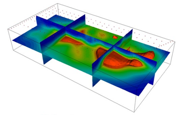
ERT involves injecting a current into the ground via a pair of electrodes, and the resulting potential field is measured by a corresponding pair of potential electrodes. The field set-up involves deploying an array of regularly spaced electrodes connected to a central control unit. Resistivity data is recorded via combinations of current and potential electrode pair to build up a cross section of apparent resistivity beneath the surface. It is also possible to create 3D models deploying the electrodes around the area of investigation.
ERT In Action
Around the two reservoirs we surveyed, a series of 144 individual electrodes were installed in a strategically calculated pattern, with around 20,000 measurements of resistivity data recorded which, after quality checking and cross-referencing were reduced to approximately 13,000 high quality readings.
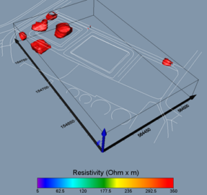
The investigation managed to reach a depth of 25m, resulting in several very clear, high resistivity, anomalies being detected.
These high values were likely to be due to air, which is a bad conductor, being present in the soil and the readings obtained pointed towards these detected volumes as being voids which could have been contributing to the issues visible on the surface.
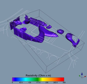
Mapping the low resistivity anomalies, likely to be caused by higher water content, shows where leakage may be present and where the water is being held in the soil.
Areas of high resistivity modelled in red below:
Areas of low resistivity modelled in blue below:
Advantages to Using ERT In Deep Areas
ERT produces highly informative results in areas of extreme depths. This technique is relatively straight forward to deploy and can be used either as a ‘one off’ with electrodes being installed, measurements being recorded then the electrodes being removed before processing, or the electrodes can be permanently installed, and measurements recorded on a regular basis.
Being permanently installed and regularly recording measurements means that situations can be constantly monitored allowing any changes to be reported on before they become a problem.
Get In Touch
This is just one of the techniques that Macleod Simmonds employ to help our clients understand the hidden environment. The team is dedicated to finding the right reporting solution to a given issue or application, with the huge range of technologies at our disposal, it is rare that we cannot find an answer to help solve those otherwise difficult to understand issues face in the world of civil engineering. If you have an issue and want the UK’s leading solution provider to investigate, please contact the team.