Unlock the Power of Accurate Surveying
In the ever-evolving water industry, precision data is the foundation for informed decisions. Whether you’re designing new water infrastructure, maintaining existing pipelines, or addressing emergency repairs, our topographical and utility surveying services enable you with the actionable insights you need. At the forefront of innovation, we combine advanced technologies and industry expertise to deliver surveys that meet the unique demands of water management projects.
Our Services
Topographical Surveys
Macleod Simmonds provides detailed topographical surveys to capture the physical characteristics of your project site. From land contours to existing infrastructure, our surveys ensure precise mapping, allowing you to plan and execute projects with confidence. By leveraging cutting-edge tools such as Ground Penetrating Radar (GPS) and Light Detecting and Radar systems (LiDar), we offer unparalleled accuracy and clarity.
Types of topographical surveys we offer:
- Full 2D and 3D topo surveys
- Building elevations
- LiDar/ laser scanning, point cloud data, BIM models
- Monitoring surveys (checking for structural movement).
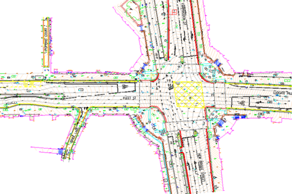
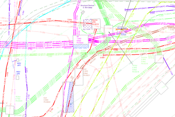
Utility Mapping
Avoid costly disruptions and ensure safety with our comprehensive utility mapping services. We locate and map underground utilities, including water pipelines, sewer systems, and drainage networks, using non-invasive techniques like Ground Penetrating Radar (GPR). Our detailed and verified utility maps are essential for avoiding damage during excavation and construction.
Types of utility surveys we offer:
- PAS128 surveys
- Pipe tracing and detection
- Sonde surveys
- Drainage surveys
All survey data can be supplied as 3D CAD models with inspection cover schedules and written reports. Our latest innovative technologies can inform your project team better than ever, via an online portal wherever the team members are based, even whilst on site.
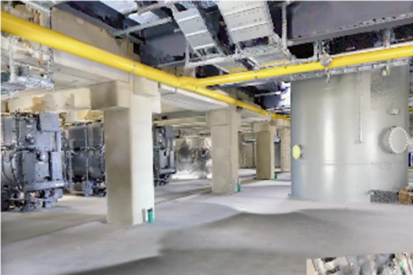
Comprehensive Digital Twins for Water Infrastructure
Imagine having a detailed, highly accurate 3D digital twin of your water infrastructure—from treatment plants to pipelines and reservoirs. Using NavVis’s advanced reality capture technology, stakeholders in the water industry can create immersive 3D models of their assets with unprecedented accuracy. These digital twins allow for:
- Improved asset management: Visualising and monitoring water treatment plant infrastructure remotely, ensuring critical assets are managed effectively.
- Enhanced maintenance: Providing a fact based facility for water industry experts to identify wear and tear without the need for on-site inspections, saving both time and resources.
- Historical data tracking: Comparing changes in infrastructure over time for better planning and risk mitigation
Optimising Workflows through Ivion’s Cloud-based Platform
The Ivion platform complements NavVis’s reality capture capabilities by providing powerful cloud-based tools for managing and sharing spatial data. For the water industry, this means:
- Seamless collaboration: Stakeholders across departments can access and interact with 3D models and data in real time, fostering better communication and faster decision-making.
- Data-driven decisions: Ivion enables integration with laser scan based point clouds and 3D imagery, together with historical data, providing actionable insights for optimising water industry related infrastructure maintenance.
- Accessible anywhere: Whether in the field or the office, Ivion’s platform ensures teams have access to the most up-to-date information at their fingertips.
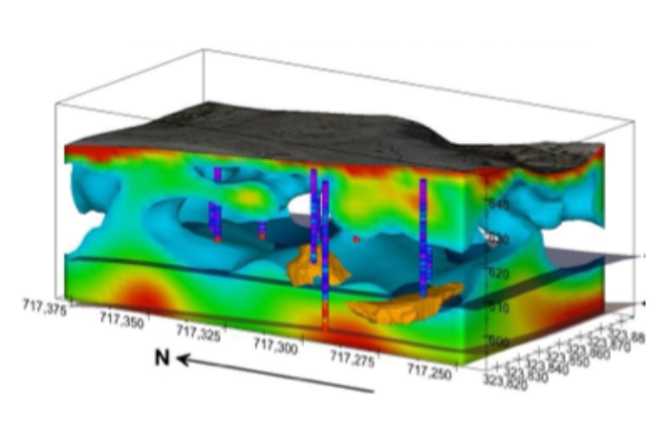
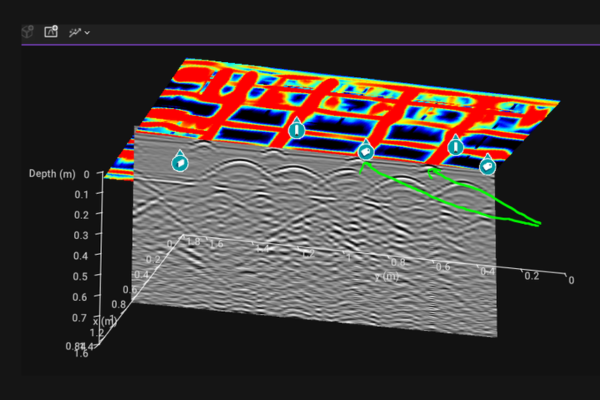
Geophysical Surveys
Our Geophysical investigation have a proven track record in locating subsurface buried structures, and have also successfully located potential leaks from underground buried reservoirs. Using Electrical Resistivity Tomography, we can locate deep sewer pipes and identify potential areas of leakage. With adequate surface space, we can map the extents of underground reservoirs and even identify potentially problematic areas surrounding these structures from the surface.
Types of geophysical surveys we offer:
- ERT surveys (looking for underground voids, sinkholes, buried structures)
- GPR surveys (looking for buried utilities, structures, reinforcement, concrete condition, voids).
GPR Concrete Inspection Surveys
Our expertise in the use of Ground Probing Radar (GPR) technology is unparalleled in the industry. Using the very latest high frequency systems Macleod Simmonds can scan concrete structures to reveal anomalies, reinforcing bars and material thickness variations. We can also define areas where the reinforcing present may be subject to corrosion within the structure.
Why Choose Macleod Simmonds?
- Industry expertise: Our team has a deep understanding of the water sector’s dynamic challenges.
- Advanced technology: We utilise the latest surveying tools and methodologies for maximum precision.
- Customised solutions: Every water project is unique, and so are our survey strategies tailored to your needs.
- Compliance guaranteed: All our surveys adhere to relevant industry standards and regulations.
Applications in the Water Industry
Infrastructure design and development
Accurate topographical and utility data is crucial when designing reservoirs, treatment plants, and distribution networks. Our services enable you to visualise site conditions and optimise your designs.
Pipeline maintenance and repairs
Pinpoint the exact location of existing pipelines and monitor for potential vulnerabilities with our utility maps. With precision data, repairs can be carried out swiftly and safely.
Flood risk management
Understand the terrain and drainage systems with our topography surveys to effectively plan flood prevention measures and water flow management.
Compliance and reporting
Our surveys are not only functional but also compliant with industry standards, ensuring that your projects meet all necessary regulatory requirements.
Partner with Macleod Simmonds for surveying excellence
The water industry demands a surveying partner who understands the intricacies of your projects. With our commitment to precision, innovation, and client satisfaction, we are the trusted choice for topographical and utility surveying. Whether you’re embarking on a new project or maintaining critical infrastructure, let us provide the data and insights you need to succeed.
Contact us today
Ready to elevate your water management projects? Reach out to our team to discuss your surveying needs and discover how we can help streamline your workflow with precision and efficiency.